
UK Manufacturer Supplies Iraq Port With Wireless Solution
Geosense has recently supplied its Wi-SOS 800 wireless solution to Archirodon as part of the new port development at Al Faw in southern Iraq
Monitoring is being carried out on dedicated cross sections in order to measure the degree of consolidation of the foundation soil and the stability of the breakwater embankment during construction.
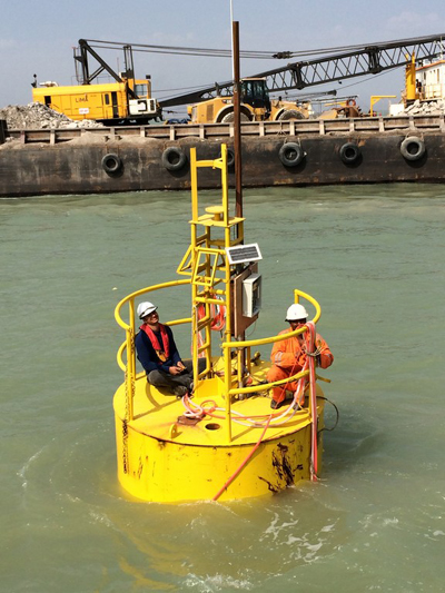
At each location multiple Push-in type vibrating wire piezometers are being installed into the seabed to various depths up to a maximum depth of 19 metres to monitor pore water pressure in the foundation soil.
As the initial installation of the piezometers will be over approximately 4-6 metres of water installation of the piezometers is being done from floating barges and the piezometers connected to a data logger situated on floating buoys at designated locations. The buoys are located at approximately 1km centres and therefore data retrieval is the challenge. Geosense proposed their Wi-SOS 400 wireless system which transmits data via radio to distances up to 8km.
Both Iraq and the broader northern Gulf region need a fully-equipped deep water sea port with sufficient capacity to handle rapidly growing volumes of international trade. The Iraqi government has identified the existing port of the Al-Faw Peninsula, where the Shatt Al-Arab meets the Gulf, to be developed to meet this need. The depth of the quays (-17.5 m) will allow the operation of the new generation of container ships. The special quays will be 7,000m long (about 20 berths). The specialist quays for moving dry bulk will be 3,500m long (about 12 berths).
A dredged channel 400m wide and 24km long will connect the new port to the deep water; dredged volumes will be approximately 60.000.000m3 for the navigation channel and 82.000.000m3 for the port basins, protected by rubble mound breakwaters approximately 15km long.The project includes 2.000.000m2 of yard for terminal container stacking, 600.000m2 for dry bulk yards and 1.000.000m2 of land yard for buildings and warehouses 200.000m3 of silos for wheat.
As part of the port development a rubble mound breakwater approximately 15km long is being constructed.
CONTACT
Martin Clegg
Geosense Ltd
info@geosense.co.uk
www.geosense.co.uk
+44 (0) 1359 270457
Wednesday 29 October 2014 / file under Electronics | Marine | Technology | Telecommunications
Strategic Partners