
3D Laser Scanning Helping Bring Games And Movies To Life
Laser scanning or Light Detection and Ranging is now common place in the film and gaming industry for pre-visualisation of scenes or in post-production creating stunning CGI and visual special effects
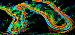
Dynascan S250 Mountain RoadThe speed and accuracy of laser scanning allows for environments, sets, objects, and people to be captured in 3D to a high level of detail and precision, in a matter of minutes.
The ability to quickly create exact copies of locations and objects has significantly reduced the time and cost of 3D modelling and visualisation and provides for more realistic VFX. Static laser scanning techniques are however limited to localised scanning of small areas or objects. With the demands for 3D data capture ever increasing there is a requirement for a mobile scanning solution that can cover large areas and complete environments.
The Dynascan 3D mobile mapping system from Renishaw subsidiary Measurement Devices Ltd (MDL), can be mounted on both vehicles and vessels and be used to capture 3D LIDAR data of topography and structures at speeds of up to 70 km/hr. The 360 degree laser in the Dynascan is capable of scanning up to 72,000 points a second to an accuracy of +/-10 mm and with a range of up to 250 metres.
Accurate 3D positioning is achieved using an in built Real Time Kinematic (RTK) differential GPS systems, which employs GNSS carrier phase differential techniques to provide real-time, centimetre-level, three-dimensional positioning. RTK correction signals are generally derived from a local RTK Base Station which will be set up over a known survey control point within the desired geodetic framework in the area of operations. The computed correction signals are then transmitted to the mobile GNSS receivers on the Dynascan over a UHF radio link. A high grade Inertial Navigation System (INS) consisting of gyroscopes and accelerometers is also used to compensate for the motion, pitch and roll of the vehicle.
The resulting geo-referenced point cloud data can be integrated with other static laser scanning data, survey data, and photogrammetry to produce a comprehensive 3D survey of a site, set, or complete landscape. High resolution still and video camera systems can also be mounted on the same vehicle to provide reference and texture information to assist with later 3D modelling and rendering.
The small size and compact nature of the Dynascan system means it can be quickly mobilised to sets and shoots anywhere in the globe. Also the rugged nature of the system means that it can be mounted on off-road vehicles and used in harsh and inaccessible terrain. The MDL Dynascan has already been used to capture high resolution Digital Terrain Models (DTM) for VFX on a number of high profile movies and to survey a number of racing circuits for the gaming industry. The speed and efficiency of mobile 3D data capture techniques offers exciting new possibilities for pre-visualisation and post production VFX that will leave game and film lovers on the edge of their seats.
CONTACT
Chris Pockett
Renishaw plc
chris.pockett@renishaw.com
www.renishaw.com
+44 (0) 1453 524524
Tuesday 12 February 2013 / file under Leisure | Technology
Strategic Partners